
Turks and Caicos National Parks
National Parks were first established in the Turks and Caicos in 1975, with the introduction of the National Parks Ordinance.
There are four categories of protection: national parks, nature reserves, sanctuaries, and areas of historical interest. Every major island in the country has at least two protected sites.
Fishing is strictly prohibited in all protected areas, with fines of $50,000 per infraction. Camping, making fires, and littering are all prohibited and carry fines.
Enforcement is handled by the Department of Environmental and Coastal Resources (DECR). Some sites, such as Cheshire Hall, Wade's Green, and Bird Rock Trail, are managed by the Turks and Caicos National Trust.
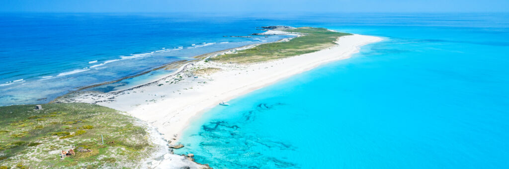
Above: Half Moon Bay in the Princess Alexandra National Park.
Top right:
Top left:
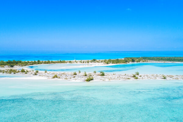
Islands in Chalk Sound National Park.
Bottom right:
Top right:
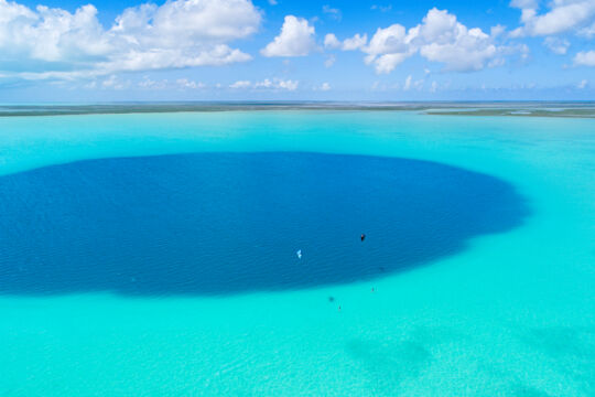
Kiteboarders at the Middle Caicos Ocean Hole, which is perhaps the widest blue hole on earth. This amazing feature is part of the Vine Point and Ocean Hole Nature Reserve.
| National Parks, Nature Reserves, and Protected Areas | |||
| National Parks | |||
| ID | Name | Acres | |
| NP1 | Admiral Cockburn Land and Sea National Park | 2,098 | Map |
| NP2 | Chalk Sound National Park | 3,608 | Map |
| NP3 | Columbus Landfall Marine National Park | 2,783 | Map |
| NP4 | Conch Bar Caves National Park | 256 | Map |
| NP5 | East Bay Islands National Park | 8,342 | Map |
| NP6 | Fort George Land and Sea National Park | 1,823 | Map |
| NP7 |
Grand Turk Cays Land and Sea National Park See Gibbs Cay, Penniston Cay, Martin Alonza Pinson Cay (East Cay) |
491 | Map |
| NP8 | North West Point Marine National Park | 4,163 | Map |
| NP9 | Princess Alexandra Land and Sea National Park | 9,494 | Map |
| NP10 | South Creek National Park | 242 | Map |
| NP11 | West Caicos Marine National Park | 1,153 | Map |
| Nature Reserves | |||
| NR12 |
Admiral Cockburn Nature Reserve See Long Cay, Six Hills Cays, Middleton Cay |
791 | Map |
| NR13 | Bell Sound Nature Reserve | 2,857 | Map |
| NR14 | Cottage Pond Nature Reserve | 19 | Map |
| NR15 | Dick Hill Creek and Bellefield Landing Pond Nature Reserve | 991 | Map |
| NR16 | Lake Catherine Nature Reserve | 979 | Map |
| NR17 | North, Middle and East Caicos Nature Reserve (Ramsar) | 144,747 | Map |
| NR18 |
North West Point Pond Nature Reserve See Northwest Point National Park |
140 | Map |
| NR19 | Pigeon Pond and Frenchman’s Creek Nature Reserve | 5,948 | Map |
| NR20 |
Princess Alexandra Nature Reserve See Little Water Cay (Iguana Island), Mangrove Cay, Donna Cay |
523 | Map |
| NR21 |
Pumpkin Bluff Pond Nature Reserve See Pumpkin Bluff |
411 | Map |
| NR22 |
Vine Point (Man O’ War Bush) and Ocean Hole Nature Reserve See Man O' War Bush and Ocean Hole |
1,838 | Map |
| Sanctuaries | |||
| S23 | Big Sand Cay Sanctuary | 442 | Map |
| S24 |
French, Bush and Seal Cays Sanctuary See French Cay, Bush Cay, Pear Cay (Seal Cays) |
31 | Map |
| S25 | Long Cay Sanctuary (Grand Turk) | 188 | Map |
| S26 | Three Marys Cays Sanctuary | 36 | Map |
| Areas of Historical Interest | |||
| HA27 | Boiling Hole Area of Historical Interest | 121 | Map |
| HA28 | Cheshire Hall Area of Historical Interest | 3.4 | Map |
| HA29 |
Fort George Area of Historical Interest See Fort George Cay |
1.2 | Map |
| HA30 | H.M.S. Endymion Wreck Area of Historical Interest | 7 | Map |
| HA31 | Molasses Reef Wreck Area of Historical Interest | .2 | Map |
| HA32 |
Salt Cay Area of Historical Interest See Salt Cay Salinas |
466 | Map |
| HA33 | Sapodilla Hill Area of Historical Interest | .14 | Map |
| HA34 |
Town Pond Salina Area of Historical Interest See Grand Turk Salt Salinas |
177.7 | Map |
| HA35 |
Red Salina Area of Historical Interest See Grand Turk Salt Salinas |
25.6 | Map |
| National Trust Protected Areas | |||
| Bird Rock Trail | 113 | Map | |
| Crossing Place Trail | - | Map | |
| Haulover Plantation | - | Map | |
| Wade's Green Plantation | Map | ||